

Mkokoni—a coastal village in Lamu County—has been associated with maritime safety incidents. Two boats transporting goods recently capsized in the Indian Ocean in the Mkokoni area.
Mkokoni is a remote island village located in the Lamu East Sub- County of Coastal Kenya. It is near the border with Somalia, often described as a “lonely island” situated several kilometers away from other surrounding islands like Kiwayu, Ndau, and Kiunga. The majority of its approximately 1,000 residents are from the Bajuni community, with others from Boni, Kikuyu, and Giriama communities. It is primarily a fishing and farming community.
The recent accident at Mkokoni Creek is a tragic and entirely avoidable reminder of the cost of neglecting basic maritime safety infrastructure. As Kenya aspires to become a regional blue economy powerhouse, the continued failure to maintain safe, well-marked channels along our coastline is no longer merely an administrative oversight.
It is a direct threat to human life, livelihoods, and our national economic future. Every day, fishers, small cargo vessels, and local operators navigate these waters at unacceptable risk—missing buoys, silted channels, and outdated charts have turned routine journeys into gambles. This must change. Immediately.
The Critical Need for IALA-Compliant Aids to Navigation
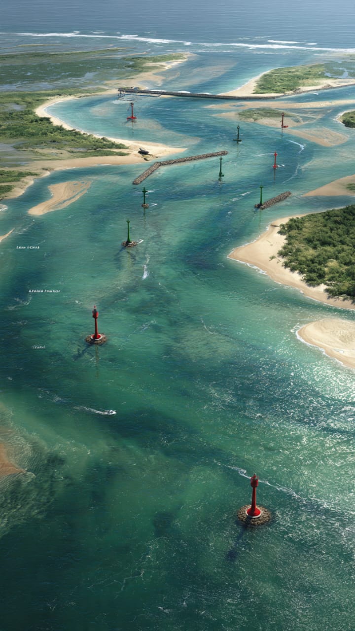
Too many of our major channels and creek approaches remain poorly marked or entirely unmarked. Mariners routinely report near-misses, conflicting vessel movements, and the constant difficulty of identifying hazards—buoys and beacons have disappeared, deteriorated beyond use, or never met international standards in the first place.
The Kenya Maritime Authority (KMA) must treat the installation of proper Aids to Navigation (AtoN) as an urgent national priority. A comprehensive audit of all critical waterways—starting with the Mkanda Channel and the approaches to Mkokoni Creek—must be launched without delay. This audit should identify every missing, damaged, or non-compliant mark and produce a clear, time-bound remediation plan.
Specifically, KMA should:
- Install lateral marks consistent with IALA Region A standards to clearly define port and starboard channel boundaries.
- Deploy cardinal marks around wrecks, shoals, and isolated dangers—many already highlighted in incident reports.
- Place special marks to signal restricted zones, submarine pipelines, ferry crossings, and other areas demanding caution.
- Align all markings with INT-1 chart standards and issue timely Notices to Mariners, ensuring navigational charts reflect reality on the water.
These are not luxuries. They are foundational requirements under international conventions that Kenya has ratified. Visible, reliable aids to navigation prevent groundings, collisions, and loss of life. Their absence is inexcusable in waters that sustain entire fishing communities, tourism, and growing cargo traffic.
Mkanda Channel: Death by a Thousand Silted Cuts
Progressive siltation and channel recession have turned the once-reliable Mkanda Channel into a treacherous maze—especially at low tide. Vessels are forced into ever-narrower, shallower alternative routes, raising the probability of exactly the kind of accident witnessed at Mkokoni Creek. When poor marking meets heavy siltation, the margin for error evaporates.
The heaviest toll falls on those who can least afford it: small-scale fishers, local cargo operators, and coastal communities whose economic survival depends on safe sea access. This is not sustainable.
KMA, in close collaboration with the Kenya Ports Authority (KPA) and Lamu County Government, must act decisively:
- Commission and publish a fresh hydrographic survey of the Mkanda Channel and adjoining Mkokoni Creek to accurately map current depths and critical shoaling areas.
- Develop and implement an emergency dredging and channel maintenance plan with clear funding responsibilities and enforceable timelines.
- Issue immediate navigational warnings through radio broadcasts, updated charts, and digital channels while remedial works are prepared.
- Introduce temporary traffic management measures—including speed restrictions and one-way traffic in constricted sections—to reduce risk during the interim.
Delay is no longer an option. Each tidal cycle without action compounds the danger and raises the eventual cost of rectification.
Time for Accountability and Action
Safety of life at sea is not negotiable. Kenya’s blue economy ambitions—whether in fisheries, maritime transport, cruise tourism, or port development—will remain hollow rhetoric if mariners cannot navigate our coastal waters with confidence. The Mkokoni Creek accident must serve as a loud wake-up call, not another forgotten file.
KMA bears primary responsibility for ensuring compliance with international AtoN standards and coordinating effective channel management. It must now demonstrate urgency, transparency, and technical competence. The private sector, county governments, and port operators should be brought into a coordinated response rather than left to manage risks in isolation.
Our coastal communities and the nation at large deserve waterways that are properly surveyed, clearly marked, regularly maintained, and transparently managed. Anything less betrays both maritime tradition and economic common sense. The technology, standards, and expertise exist. What has been missing is the will.
Let the Mkokoni Creek accident mark the moment that finally changes that. The lives of Kenyan seafarers—and the future of our blue economy—depend on it.